Sunday, December 25, 2011

BATANGAS│(Mt. Gulugod Baboy+Mt. Talmitam: Part II) Mt. Talamitam

Mt. Talamitam48
Hiking two mountains in one day is really a challenge. So after hiking Mt. Gulugod Baboy, we went to our next stop, Mt. Talamitam at Nasugbu Batangas.

Several months ago, I noticed this mountain viewed from Kaytitinga I, Alfonso Cavite, I already started mountain climbing then, and asked my BF, a kinda resident there if it's possible to climb that "unknown mountain" for me back then. Well, most of them, the locals said that there are NPAs hiding on that beautiful mountain from afar.

Upon browsing the internet for mountains near Cavite for our 2nd half climb, which are Laguna and Batangas, I found Talamitam. At first we were thinking where at Batangas this could possibly be, because all I knew was Batulao and that "unknown mountain" that were nearest.

After 2 hours of travel from Mt. Gulugod Baboy at Mabini Batangas, we finally reached Nasugbu.Upon entrance then turned left, we reached Brgy. Aga for 5 mins, then Sitio Bayabasan. You can identify jump-off going to the mountain by simply finding Bayabasan Elementary School on the right side of the road and beside pf it is a cemented path going to the registration area and straight ahead to the mountain.

TRAIL
Mt. Talamitam
After registration at brgy. hall-like beside residences, P35 each day or night hike, we headed straight ahead. 

Mt. Talamitam1
Along the way you will hear the lush of the Bayabasan River found on your left side.
Mt. Talamitam2
Five minutes from the registration area, you'll reach these two bridges. Just cross those and took the left path.

Mt. Talamitam3
The river underneath the bridge 1.
Mt. Talamitam4
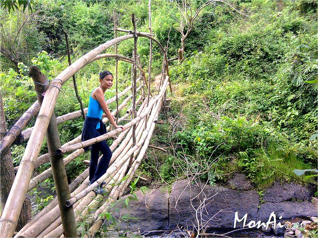
Bridge 2, the bamboo bridge.
After crossing the bridges, you'll experience forested area for almost 30-45 minutes walk and then exit to grasslands.
Mt. Talamitam7
Uphill walk, stayed and relaxed to view Mt. Batulao for awhile.
Mt. Talamitam10
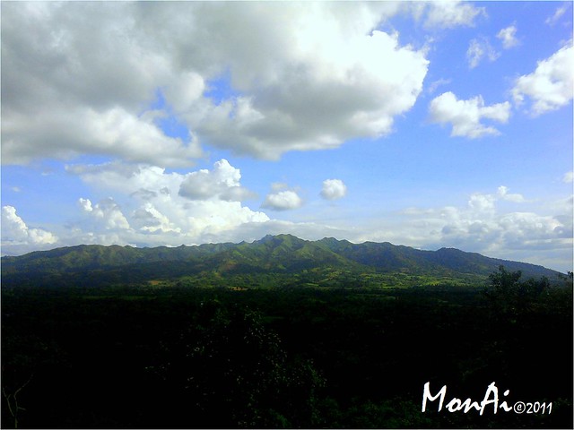
Mt. Batulao, hill's view. :)
Mt. Talamitam58
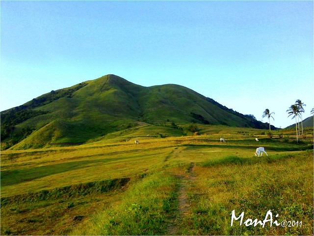
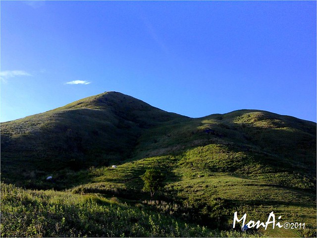
The unshaded hut, but still a help in spite of intense sunlight, a resting spot. From here you can view the Talamitam's perfect landscape for the first time.
Mt. Talamitam11
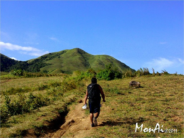
Trail was not well defined because of plenty crop fields around the area. Moreover gangster cows and horse are everywhere that we tend to walk distant from them and try other paths to reach the foot of the mountain. In short we made our own trail, it's not hard to locate the trail to summit anyway. If you think you are lost, just look at the mountain, and walk straight ahead! hehe...seriously! :D

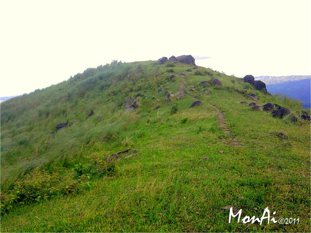
From the mountain's foot, 3 trails going to the summit are visible. If you are going to measure the distance of 3 different trails viewed from the grasslands, you will definitely choose the middle. 

Mt. Talamitam44
We took the middle trail expecting to reach the top in shorter time without realizing that it is steeper and slippery because of rocks. Well, after 1 hour of hike from mountain's base, 2 hours in total from the jump-off, we reached the zenith of Mt. Talamitam.

SUMMIT
Mt. Talamitam26
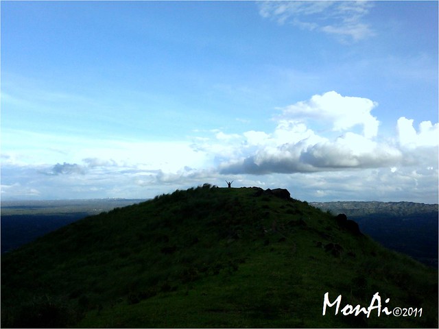
My solo photo shot at the summit :)
Mt. Talamitam20
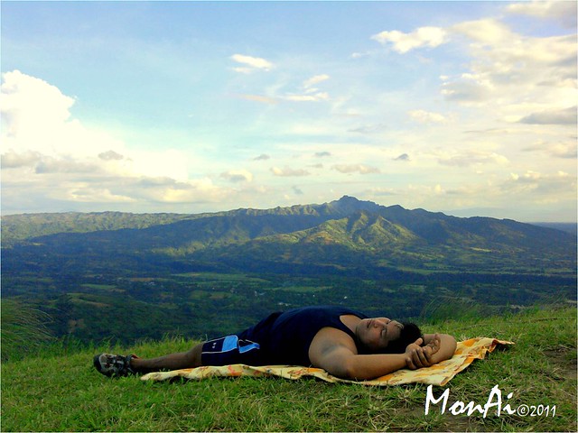
Surprisingly, we were the only hikers in the mountain's summit. It was so relaxing, so peaceful. :)
Mt. Talamitam36
Another picture of Mt. Batulao.
Mt. Talamitam17
This shot was amazing for me, it was like Jesus will descend from clouds. 
PANORAMIC VIEWS
Mt. Talamitam18
Mt. Batulao on left. 
Mt. Talamitam19
Now Batulao on right.
Mt. Talamitam30
Rocky part of the summit.

DESCENT
After 45 minutes stay at the summit, we took the left most path for our descent to experience other trails and avoid that steep and slippery way we went from our ascent.

Mt. Talamitam38
Boulders from few meters from the zenith.
Compared to our first trail, path was slightly covered by tall grasses as high as human and long walk yet not steep, perfect for descent.
Mt. Talamitam42
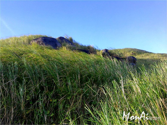
Looking back to our descent trail.
Mt. Talamitam41
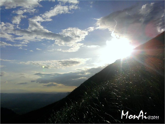
Sun peeping from the other side of the mountain.
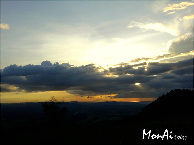
Mt. Talamitam57
Sunset.
Yey! we arrived at the jump-off  after 1 hour and 30 minutes, it was already 5:30pm started 1:00pm.
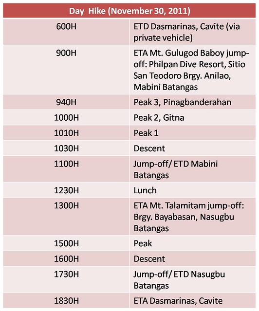
ITINERARY
ITINERARY-Gulugod Baboy

CHECKLIST
Checklist-Gulugod Baboy

BUDGET
Budget-Gulugod Baboy

Mt. Talamitam25  
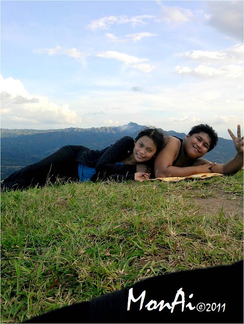
November 30, 2011, we climbed two day hikes in one day, just the two of us (me and my bf). Because it was holiday, "Bonifacio day" it fells on a weekday that made summit unpopulated. We owned the mountain that day! That was our 6th mountain and I'm very happy for that. Well, I just started to fall in love with mountain climbing and hoping to conquer more! :)

BATANGAS│(Mt. Gulugod Baboy+Mt. Talamitam: PartI) Mt. Gulugod Baboy: The Easiest Climb, Perfect for Novice Climber.

After searching on web for an easy and Batangas area mountain for our first day hike, I finally found Mt. Gulugod Baboy at Mabini Batangas. Gulugod ng baboy, "Pig's spine is" is how they describe this mountain and I kept on imagining how or on what angle this description would really be obvious.

Because it's our first day hike and first time for just the two of us to climb, Lovers' Lakwatsa (me and my bf) decided to bring car for an easier and convenient travel. This is one disadvantage of climbs with few people, more transpo expense.

After three hours of travel from Dasmarinas, Cavite via private vehicle, we finally found Philpan Dive Resort at Sitio San Teodoro Brgy. Anilao, Mabini Batangas, the jump off.
 Because we're blessed to bring our car in this trek, we were able to skip the cemented steep road, thanks to "Red" our dearest car rolled all the way up until we reached this uphill path to the mountain. Well, we can't bring red to peak from here so we parked and left him beside a store.

Placard says "This way to Gulugod Baboy", and "Guide Gulugod Baboy P350"
TRAIL
Trail is quite easy but there are some path going to different houses that made it kinda confusing. You have to pass residences so be courteous. Also the hardest part here for me were the "gangster dogs", hehe... There were lot's of them, some walked closer to you, barked a lot and looked like they'll bit your leg, but thank God they aren't, they're just expecting you to give them some food.

Along the trek up, try to turn your back and see the amazing view of Batangas' bluish waters and floating Islands from a far including Sombrero Island.

Because of the mountain's grassland state, there are cows and goats graze and roam along the area. Moreover, because of absence of trees upon approaching the mountain, temperature was totally increased, I tend to sat and hide myself  on tall grasses, hehe.

After forty minutes of walk from where we parked our car, we reached "Pinagbanderahan", (peak 3), place where flag was raised in english.
Pinagbanderahan Peak viewed from peak 2.

After taking pictures, we're off to peak 2
Gulugod Baboy Peak 2, The "gitna" or middle.
Panoramic view from Peak 2, with Peak 3 on left side and Peak 1 on right.

Actually when we saw the peaks, we were surprised due to proximity of those to each other, that's why I was puzzled about the itineraries written in blogs with about 40mins to 1 hour of walk (?).

After taking pictures at peak 2, we went to Peak 1.
Gulugod Baboy Peak 1. Well, It's just me, the grass and the baby tree. Poor plant, it went down by strong winds and dried by too much sunlight.
Enticing panoramic view from peak 1, with Sombrero Island and Maricaban Island floating over there. :)
This first day hike was nice, easy yet memorable because it's the first time were able to hike without anyone to follow, just ourselves (with fear of chance of getting lost), instincts and the trail. Sometimes its fun to be with your bf/gf in a certain place without any people knowing that you were there, but of course it's also fun in a group hike, getting laud and laugh a lot and most of all you won't have a hard time taking picture by yourselves. . haha.

DESCENT
After taking lots of pictures and experiencing Mt. Gulugod Baboy's peaks, we started our descent and took the same trail in our ascent.

We didn't spent too much time at the peaks 'cause we planned to hike our next mountain that day, Mt. Talamitam.

ITINERARY

CHECKLIST

BUDGET

Mt. Gulugod Baboy climb, November 30, 2011, our 5th mountain, was so memorable, it was our first time to do day hike and conquer two peaks in a day together, just the two of us. Because it's our first time here, I just noticed that the trail up is always left, so if you're like us (first timers here) better go with left path. On the other hand, this climb was romantic for me, me and my bf at the zenith!. :)

CARAMOAN│6 Islands in Half Day at Caramoan

After our day one Naga tour, we went to Caramoan Islands from Sabang port to Guijalo. From our Hotel in Naga, we were fetched by the owner of the Hostel, Hotel Roa in Caramoan, Dr. Ramon Roa, 6AM in the morning then headed and arrived 8AM to Sabang port, waited for the next ferry boat.

We arrived around 1:00PM at Hotel Roa,  had our lunch, off to Bikal port to start our adventure.

Islands Explored

Matukad Island
From a far, you'll see this beautiful huge rock inviting you to swim on its bluish waters from your boat up to the shore. This view is just a glimpse and be ready to unveil the beauty you never seen before and I tell you, you don't want to leave this Island after your first step! read more...


Lajos Island
After Matukad Island visit, we went to another Island named Lajos or Lahos which means "overflow" because the sea can wash over a part of this narrow island from one side to the other. Vewing from a far, you'll see a beautiful Island, it's like two separated rocks situated on a flat white sand paper and can be appreciated only during low tide. read more...

Cagbalinad Island
Island is so rich in marine life, you can see how much fish enjoy swimming with you without any feed (bread to attract fishes) and corals beautifully arranged under. It's like 5-10 meters away from the shore where this experience is no way impossible! read more...

Hunongan Island
Another mesmerizing private beach in Caramoan group of islands is Hunongan beach resort which is also near famous private resort, Gota beach. From afar, while passing here fromCagbalinad Island, we really saw its white, clean beach front adorn with cute hut accommodations and turquoise waters. read more...

Minalahus Island
Our last Caramoan Island destination was Minalahus Island. This Island is similar to other Islands but compared to others, majority of it is rock formation proportion as to white sand, (about three fourths). read more...

Lampikaw Tablet Rock
After that interesting Island hopping experience, we went back to Bikal port and saw this interesting rock form from afar. read more...

CARAMOAN│Lampikaw Tablet Rock

After that interesting Island hopping experience, we went back to Bikal port and saw this interesting rock form from afar.

This Lampikaw Tablet Rock might be familiar to those foreign survivor fans not just beacause of nice location but because of memorable challenge happened here.

It's like an isolated rock, sprouted away from the rock formation beside it.

Like what I mentioned earlier, this was one of the location of foreign Survivor TV show, but unfortunately, that wooden structure is just a remnant due to typhoon stucked Caramoan and casted it away to another island, the Minalahus Island. Because of it's incompleteness, we weren't able to experience the survivor excitement contestants had before.

 
Design by Free WordPress Themes | Bloggerized by Lasantha - Premium Blogger Themes | Facebook Themes